


A property owner has his building scanned. A few weeks later, he receives a point cloud several gigabytes in size, whilst his architect was expecting plans. This sort of misunderstanding happens often, yet it can easily be avoided if you know what a 3D survey can produce and how to commission one.
From point cloud to plan
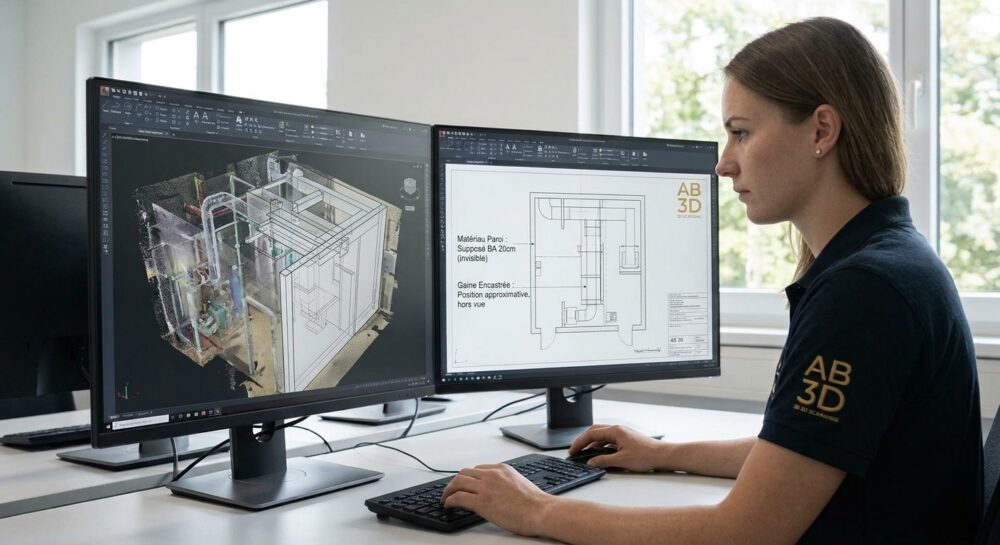
The laser scanner records millions of points that reproduce the building’s actual geometry. This point cloud contains a great deal of information, but nobody works directly on it as they would on a plan. It must first be sliced into horizontal and vertical sections. A draughtsman then plots the walls, openings and levels based on these sections.
The plan is therefore drawn from the scan, with representation choices made by a person. The quality of the result depends as much on this drafting work as on the on-site capture.
The most common 2D deliverables
Floor plans
A floor plan is a horizontal section taken at a standard height above ground level. It shows walls, partitions, doors and windows, staircases and fixed fixtures. For a complete survey, every level is drawn, including basements and attics.
Sections
Sections show floor heights, slab thicknesses, floor levels and the shape of the roof. Whenever a project alters the building’s volumes – such as by adding a storey or converting an attic – sections are essential.
Facade elevations
An elevation shows a façade from the front, without perspective. It can be a simple line drawing. It can also be supplemented by an orthophoto – a rectified, scaled photograph showing the actual materials. For an old building, this is often the most useful image.
Roofs and details
A roof plan or details of the cornice, staircase or joinery are included where the project requires them.
| Deliverable | What it shows | Typical use |
|---|---|---|
| Floor plan | Walls, openings, circulation routes, fixed fittings | Conversion, fitting-out, area calculations |
| Cross-section | Heights, floor slabs, levels, roof | Extensions, loft conversions, compliance with building regulations |
| Elevation | Openings, mouldings, materials | Facade renovation, planning application |
| Orthophoto | Actual appearance to scale | Restoration, damage assessment |
| Detailed plan | Large-scale individual elements | Construction, joinery, heritage |
What the Swiss regulatory framework requires of these plans
The SIA 400 standard sets out the rules for drawing up planning documents in the construction sector. It also covers the updating of plans for completed works and their archiving. 3D surveying falls within this framework, as it is specifically used to update the documentation for an existing building.
When it comes to planning permission, it is then the cantons and municipalities that specify what they require.
- In Valais, the municipality of Evolène refers to the 2017 Cantonal Building Ordinance and requires plans drawn to professional standards, at a scale of 1:50 or 1:100. For a major conversion, it also requires an elevation survey of the existing building, with existing parts shaded in grey, areas to be demolished in yellow and proposed parts in red
- In Geneva, the Building Permits Office advises that plans, sections and elevations for all storeys – including basements, cellars and attics – should be dimensioned, always stating the scale
- In the canton of Vaud, a form for developments outside building zones requires elevations and sections where the current state is shown in black, works in red and demolition areas in yellow
Colour codes therefore vary from place to place. In every case, however, the project is based on the existing condition. If this is poorly surveyed, any drawings superimposed on it will inherit those errors.
Technical installations, moreover, follow their own conventions. The SIA 410/1 and 410/2 recommendations concern plans of existing installations and recesses. We have devoted an article to CVSE surveys using 3D scanning.
Scale, level of detail and accuracy
These three parameters are decided before the scan, and they are interdependent.
The scale determines what appears on the plan. At 1:100, a moulding or the reveal of a window is no longer visible. At a scale of 1:20, on the other hand, every detail must be drawn, and the time required for the work increases accordingly.
The level of detail addresses very specific questions. Do we draw radiators, skirting boards and washbasins? It all depends on what the plan will be used for, just as with a BIM model. Our article on the level of detail in BIM in Switzerland explores this topic.
As for accuracy, this is specified in the brief, along with how it will be verified. You’ll find further details in our article on the accuracy of a 3D survey.
What a scan does not show
The scanner only measures the surfaces it can see. The structure hidden behind cladding, recessed ducts or the composition of a wall are not captured. These are identified through probing, old documents or on-site observations.
The plan must highlight this distinction. A legend or a specific line is often sufficient to distinguish between what has been measured and what has been inferred, and the reader then knows to what extent they can rely on the drawing.
How to order your plans
- Specify the purpose of the plans: planning permission, design, construction or building management
- List the required floor plans, sections and elevations, specifying where the sections are to be taken
- Specify the scale and level of detail
- Specify the delivery format – DWG and PDF, for example – and provide your office’s layer template
- Please also keep the point cloud, which will allow us to check a dimension or add a section at a later date
To conclude
A single survey can provide plans, sections, elevations and, one day, a BIM model. However, what you get out of it depends on what was decided before we go out onto site.
At AB 3D Scanning, we work with you to determine the intended use, scale and level of detail before carrying out the work, and then we deliver plans tailored to your project. Are you planning a refurbishment or putting together a planning application? We’d be happy to discuss this with you.
Sources
- SIA, standard SIA 400:2000 ‘Preparation of drawing sets in the building sector’ (available from the SIA shop)
- CRB, CAN 461 F/2022, general guidelines, which refer to SIA recommendations 410/1 and 410/2
- Republic and Canton of Geneva, Building Permits Office, ‘How to succeed with your building permit application’ (May 2022)
- Canton of Vaud, DGTL, Form 66B for buildings outside designated building zones (August 2022)
- Municipality of Evolène, documents to be submitted with a building permit application (January 2018)